Search
26 Mar 2026
Search
26 Mar 2026
Please allow ads as they help fund our trusted local news content.
Kindly add us to your ad blocker whitelist.
If you want further access to Ireland's best local journalism, consider contributing and/or subscribing to our free daily Newsletter .
Support our mission and join our community now.
To continue reading this article, you can subscribe for as little as €0.50 per week which will also give you access to all of our premium content and archived articles!
Alternatively, you can pay €0.50 per article, capped at €1 per day.
Thank you for supporting Ireland's best local journalism!

A solar farm. Image: Pexels

A planning application on a proposed huge solar farm in Laois has been placed on hold.
Laois County Council says the plan for the project on 37 fields near Emo, which was due for decision this week, is on hold.
For the second time, planners have requested Further Information from the applicants, Danish renewable energy company Orsted.
The solar panel farm is proposed on five land parcels in townlands Morett, Killone, Cappakeel, Rossmore and Raheennahown North in Laois.
The fields on a stretch of almost 5 km, would house 1,796,838sq. metres of solar photovoltaic panels on ground mounted steel frames, with underground power and communication cables and ducts, and 22,753 metres of fencing.
It had received a whopping 86 objections from members of the public and Laois politicians. Read more on the objections here.
The planning now seek extra information before they can make any decision.
They want to know how Orsted will address the public's concerns, and have many queries themselves.
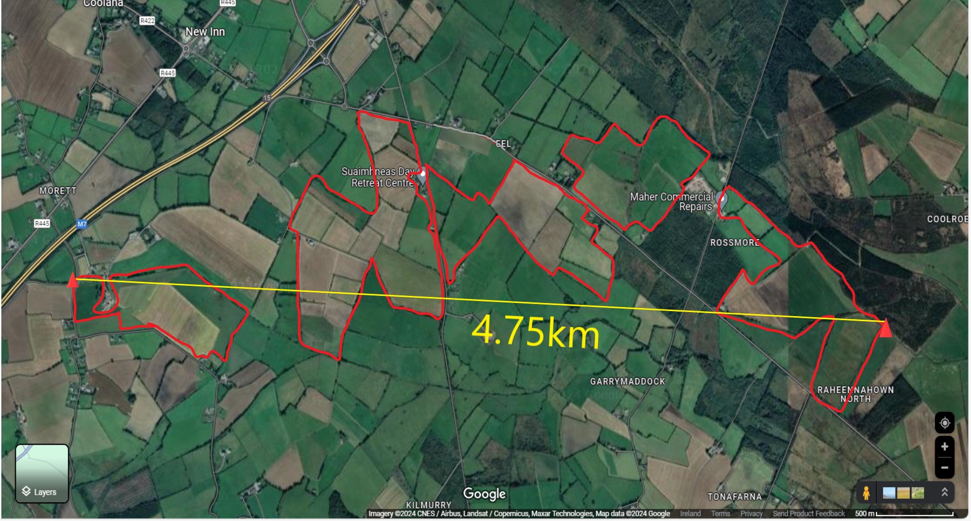
Map of the proposed solar farm near Emo.
They want a plan showing the proposed removal of 300 metres of hedgerow, and recontouring of the land so the panels are out of flood risk. They say they will then decide if an Environmental Impact Assessment will be required.
They want a new Glint and Glare assessment because it covered panels up to 2.6m high but the plan is for up to 3.2m high.
An assessment is sought on the impact on scenic views.
Planners say there are 11 approved solar developments within 15km of the site, so they ask for a Cumulative Impact Assessment.
They also ask for an impact on the Ballyprior Grassland SAC to be considered.
The planners also note that links to references are getting a 'file not found' message.
As the TII said that the farm "would endanger public safety by reason of traffic hazard due to its scale and distraction of drivers", the applicant is asked to comment.
Inland Fisheries pointed out contradictions in the application, and made 24 points. They say there is no justification shown for putting the farm in a 1% flood risk zone. They ask for maps to show culverts, and want the plan changed so it is 50m distance from any surface water, and above the 1% AEP level.

Subscribe or register today to discover more from DonegalLive.ie
Buy the e-paper of the Donegal Democrat, Donegal People's Press, Donegal Post and Inish Times here for instant access to Donegal's premier news titles.
Keep up with the latest news from Donegal with our daily newsletter featuring the most important stories of the day delivered to your inbox every evening at 5pm.
This publication supports the work of the Press Council of Ireland and Office of the Press Ombudsman, and our staff operate within the Code of Practice of the Press Council. You can obtain a copy of the Code, or contact the Council, at www.presscouncil.ie, Lo-call 1800 208 080 or email: info@presscouncil.ie.


