Search
07 Mar 2026
Search
07 Mar 2026
Please allow ads as they help fund our trusted local news content.
Kindly add us to your ad blocker whitelist.
If you want further access to Ireland's best local journalism, consider contributing and/or subscribing to our free daily Newsletter .
Support our mission and join our community now.
To continue reading this article, you can subscribe for as little as €0.50 per week which will also give you access to all of our premium content and archived articles!
Alternatively, you can pay €0.50 per article, capped at €1 per day.
Thank you for supporting Ireland's best local journalism!

Met Éireann forecaster Gerry Murphy presents the weather warning forecast on RTÉ

Met Éireann has warned of "potentially devastating" winds as Storm Atiyah has been upgraded to a Status Red weather event for one county during part of Sunday.
In the latest Met Éireann forecast after the RTÉ news on Sunday meteorologist Gerry Murphy delivered the latest on the powerful storm which includes a Status Red warning for Kerry this afternoon. While the Munster county would be worst hit, the forecaster warns that the storm will have an impact nationwide.
What is normally a weekly farming forecast changed to due the severity of the storm.
"The most significant weather is in the short term Status Atiyah is fast approaching. It is going to bring very windy or stormy conditions across most of the country for the rest of today and tonight," he said.
The forecaster said Met Éireann has upgraded the wind warning for Co Kerry to a Status Red between 4pm and 7pm on Sunday evening.
"Northwest winds are expected to gust over 130kms per hour. These are very extreme and very damaging and devastating winds. So do heed all warnings and take all precautions for the rest of the day," he said. MORE BELOW PICTURE FROM MET Éireann.
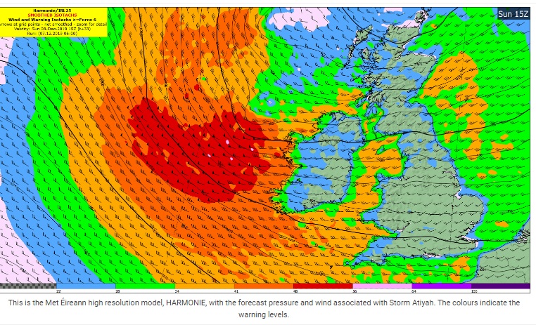
Outside these hours he said Kerry would be covered by the Status Orange alert for stormy, severe and damaging gusts. This warning is in place for all the counties along the west coast. These counties will be hit this afternoon, evening and early tonight.
The Met Éireann forecaster warned that the rest of Ireland will also be impacted by the worst of the conditions during the evening and tonight. The Yellow warning features gusts of up to 110km/hr with very strong and gusty winds expected.
"The rest of the country will be very windy as well. A Yellow level warning will be in operation but certainly at the upper end of the yellow wind warning. So, all areas can expect strong winds as we go through the rest of the day," said Mr Murphy.
Apart from the wind, the day will be marked by very heavy rain showers, some of hail and thunder.
He said the storm will have cleared on Monday but it would be an overall, wet and windy week. DETAILS OF WARNINGS BELOW TWEETS.
A mix of sunshine & frequent blustery or squally showers today, some heavy with hail and thunder, as Storm Atiyah brings very windy conditions across the country today. Severe and potentially damaging gusts will develop later this afternoon and evening in west Munster. Highs 6-8C pic.twitter.com/4uhMdZjGZU
— Met Éireann (@MetEireann) December 8, 2019
Our Atlantic chart shows precipitation and pressure forecast in 6 hour intervals for the next 7 days.https://t.co/9Giuj4CR5m
— Met Éireann (@MetEireann) December 8, 2019
The national forecast and the national outlook for the next few days is available here. https://t.co/9gKN6SVok4 pic.twitter.com/eBxKJ7z52A
NATIONAL WARNINGS IN FORCE ON SUNDAY
Status Red - Wind warning for Kerry
Storm Atiyah: West to southwest winds veering northwest will reach mean speeds in excess of 80km/h with gusts in excess of 130km/h for a time this evening. Extreme caution is advised, especially near the coast and on high ground.
Due to a combination of high seas and storm surge there is a possibility of coastal flooding.
Valid: Sunday 08 December 2019 16:00 to Sunday 08 December 2019 19:00
Status Orange - Wind warning for Donegal, Galway, Leitrim, Mayo, Sligo, Clare, Cork, Kerry and Limerick
Southwesterly winds, later veering northwesterly, will reach mean speeds between 65 and 80 km/h with gusts between 110 and 130km/h, possibly higher in exposed coastal areas.
Due to a combination of high seas and storm surge there is a possibility of coastal flooding.
Valid: Sunday 08 December 2019 13:00 to Monday 09 December 2019 06:00
Status Yellow - Wind warning for Leinster, Cavan, Monaghan, Roscommon, Tipperary and Waterford
Southwesterly winds, later veering northwesterly, will reach mean speeds between 50 and 65km/h with gusts between 90 and 110km/h.
Valid: Sunday 08 December 2019 13:00 to Monday 09 December 2019 06:00
Status Yellow - Rainfall warning for Donegal
Rainfall accumulations of 30 to 40mm expected during the period.
Valid: Saturday 07 December 2019 18:00 to Sunday 08 December 2019 18:00
MARINE WARNINGS
Status Orange - Gale Warning
Westerly winds veering northwesterly will reach gale force 8 to storm force 10 at times today and tonight on All Irish Coastal Waters and on the Irish Sea, with violent storm force 11 on Irish Coastal Waters from Mizen Head to Loop Head to Slyne Head for a time this evening and early tonight.
MET ÉIREANN WEATHER WARNINGS EXPLAINED
Read also: WATCH VIRTUAL COVERAGE OF STORM LIVE

Subscribe or register today to discover more from DonegalLive.ie
Buy the e-paper of the Donegal Democrat, Donegal People's Press, Donegal Post and Inish Times here for instant access to Donegal's premier news titles.
Keep up with the latest news from Donegal with our daily newsletter featuring the most important stories of the day delivered to your inbox every evening at 5pm.
This publication supports the work of the Press Council of Ireland and Office of the Press Ombudsman, and our staff operate within the Code of Practice of the Press Council. You can obtain a copy of the Code, or contact the Council, at www.presscouncil.ie, Lo-call 1800 208 080 or email: info@presscouncil.ie.


