Search
08 Mar 2026
Search
08 Mar 2026
Please allow ads as they help fund our trusted local news content.
Kindly add us to your ad blocker whitelist.
If you want further access to Ireland's best local journalism, consider contributing and/or subscribing to our free daily Newsletter .
Support our mission and join our community now.
To continue reading this article, you can subscribe for as little as €0.50 per week which will also give you access to all of our premium content and archived articles!
Alternatively, you can pay €0.50 per article, capped at €1 per day.
Thank you for supporting Ireland's best local journalism!

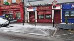
Snow hit Dublin Road in Portlaoise on Thursday morning

Met Éireann has issued Status Orange alerts as snow continues to fall in Laois on top of an already blanketed county and the forecaster says we're not out of the woods yet.
The worse of the white stuff is yet to fall in Laois according to the up-to-date forecast for Ireland from Met Éireann which has issued a Status Orange alert for the county and Leinster for Thursday night going into Friday morning.
The alert warns that significant accumulations are expected.
A Status Yellow alert is in force for all of Ireland through Thursday. A Status Orange alert has been issued for parts of the west and northwest and some midland counties through the day. More on what's to come below tweet.
⚠️ Yellow Weather Advisory - Snow/Ice/Low Temperature ⚠️
— RSA Ireland (@RSAIreland) March 8, 2023
❄️ Widespread icy stretches across the country. Accumulations of snow clearing eastwards. Possible Impacts:
● Hazardous driving conditions
● Travel disruption
● Poor visibility
(1/2) pic.twitter.com/kuvj2Gpqsm
National Forecast issued at: 09 March 2023 10:58
Thursday: Rain, sleet and snow will continue to spread northeastwards to most areas with poor visibility and hazardous road conditions in some parts. Afternoon highs of 0 to 3 degrees generally, but significantly milder in southern coastal areas. Northeasterly winds will freshen this afternoon and it will become rather windy for a time this evening.
Cold and windy at first at night with falls of sleet and snow in many areas giving rise to very poor visibility and hazardous road conditions. The sleet and snow will continue overnight over the eastern half of the country, but it will become drier further west with frost and ice developing under clear breaks. Lowest temperatures of -4 to 0 degrees coldest in the west, with northerly winds gradually easing light to moderate overnight.
Friday: Residual rain, sleet and snow in the east will clear into the Irish Sea early on Friday morning, giving way to a cold and mostly dry day with sunny spells. Highest temperatures of 4 to 7 degrees in light variable breezes.
Dry in many areas to begin on Friday night but with cloud gradually thickening from the southwest. Rain in the southwest will spread northeastwards over Munster and parts of Connacht and Leinster overnight, falling as a wintry mix of sleet and snow initially. Lows of -3 to +3 degrees, generally but locally colder in the northeast where snow is lying and skies remain clearest the longest. Light to moderate southeast breezes will be fresher near west and southwest coasts.
Saturday: Rain, sleet and snow will continue to extend northeastwards over the country on Saturday morning with transient accumulations across Connacht, Ulster and parts of Leinster before a clearance extends from the southwest during the afternoon and evening. Afternoon temperatures will range from 1 to 2 degrees in the north to 12 or 13 degrees in the southwest. Moderate and occasionally gusty southeast winds, fresh to strong near coasts, will veer west to southwest as the rain clears.
The last of the rain and sleet will clear the northeast early on Saturday night and most places will be dry with variable cloud and clear spells for a time. Cloud will thicken countrywide later in the night and patchy rain and drizzle will develop in the western counties towards morning. Moderate southwest winds will be fresh to strong near coasts. Minimum temperatures of 2 to 6 degrees will occur early on with temperatures ranging 4 to 8 degrees overnight.
Sunday: Becoming wet and windy. Rain will become widespread during the morning, before transitioning to showers in the afternoon and evening. Afternoon highs of 10 to 14 degrees in moderate to fresh and gusty southerly winds, strong near coasts. A windy night on Sunday with showers or longer spells of rain. Lows of 6 to 9 degrees generally, but 4 to 6 degrees in Ulster. Fresh to strong and gusty southwest winds with gales in some sea areas.
Monday: Scattered showers to begin, but becoming mainly dry with sunny spells for a time in the afternoon. Another spell of rain will arrive from the Atlantic towards evening. A windy or breezy morning with fresh to strong and gusty west to northwest winds easing light to moderate in the afternoon. Afternoon highs of 5 to 8 degrees in the north, 9 to 12 degrees further south.
Further Outlook: Unsettled with a mobile Atlantic regime predominating - wet and breezy spells alternating with short intervals of drier and brighter conditions. Temperatures generally trending near to above average.

Subscribe or register today to discover more from DonegalLive.ie
Buy the e-paper of the Donegal Democrat, Donegal People's Press, Donegal Post and Inish Times here for instant access to Donegal's premier news titles.
Keep up with the latest news from Donegal with our daily newsletter featuring the most important stories of the day delivered to your inbox every evening at 5pm.
This publication supports the work of the Press Council of Ireland and Office of the Press Ombudsman, and our staff operate within the Code of Practice of the Press Council. You can obtain a copy of the Code, or contact the Council, at www.presscouncil.ie, Lo-call 1800 208 080 or email: info@presscouncil.ie.