Search
04 Apr 2026
Search
04 Apr 2026
Please allow ads as they help fund our trusted local news content.
Kindly add us to your ad blocker whitelist.
If you want further access to Ireland's best local journalism, consider contributing and/or subscribing to our free daily Newsletter .
Support our mission and join our community now.
To continue reading this article, you can subscribe for as little as €0.50 per week which will also give you access to all of our premium content and archived articles!
Alternatively, you can pay €0.50 per article, capped at €1 per day.
Thank you for supporting Ireland's best local journalism!

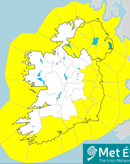
The nationwide Met Éireann weather warnings for Wednesday, April 12

It's back to hibernation season this Spring in Laois and across Ireland with national weather warnings issued and temperatures to plunge.
Laois is included in a nationwide yellow weather warning for wind issued by Met Éireann, from 8am to 8pm, on Wednesday, April 12.
The Status Yellow - Wind warning is for all of Leinster, as well as Cavan, Donegal, Monaghan, Leitrim, Roscommon, Sligo, Tipperary, Waterford.
"Very strong northwest winds developing. Widespread gusts of between 90 and 110 km/h expected, stronger in exposed areas".
On Tuesday, April 11, much of Leinster up to the Laois border was under a Status Yellow - Wind warning until 11pm, as rain and wind batters the island.
"Strong southerly winds, veering westerly. Very strong gusts expected for a short time this afternoon and evening, causing some disruption."
"Rain has extended to all areas with some heavy downpours later today. Blustery with fresh and gusty southerly winds later veering west, and becoming very windy in the south and east of Leinster for a time later this afternoon and evening. Highest temperatures of 9 to 11 degrees."
Met Éireann's forecast for Leinster including Laois:
"Wet and very windy on Wednesday morning with very strong and gusty northwest winds, and gales in coastal areas. Drier and brighter weather will develop later in the afternoon with scattered showers. Highest temperatures of 7 to 9 degrees.
THURSDAY: A mix of sunny spells and showers, with cloud cover increasing from the south later on. Light or moderate westerly winds, fresher along the north coast. Highest temperatures of 9 to 12 degrees.
THURSDAY NIGHT: A spell of rain over the southern half of the country, mainly dry further north with clearest skies near the north coast. Light variable or northeast winds, breezier along the south coast. A touch of grass frost possible in the north with temperatures near freezing or slightly below. Lows of 4 or 5 degrees in the south.
FRIDAY: A cloudy start with rain lingering for a time in the east. Sunny spells will develop along with showers in a moderate northwesterly airflow. Highest temperatures of 9 to 12 degrees. Friday night will be mainly dry with winds becoming calm. Lowest temperatures of 0 to 4 degrees.
SATURDAY: A dry and bright start but it will turn cloudy with a spell of rain later spreading from the Atlantic. Highest temperatures of 10 to 13 degrees. Moderate southerly winds will later develop.
FURTHER OUTLOOK: Becoming warmer on Sunday with cloudy weather and patchy light rain, along with light or moderate southerly breezes.

Subscribe or register today to discover more from DonegalLive.ie
Buy the e-paper of the Donegal Democrat, Donegal People's Press, Donegal Post and Inish Times here for instant access to Donegal's premier news titles.
Keep up with the latest news from Donegal with our daily newsletter featuring the most important stories of the day delivered to your inbox every evening at 5pm.
This publication supports the work of the Press Council of Ireland and Office of the Press Ombudsman, and our staff operate within the Code of Practice of the Press Council. You can obtain a copy of the Code, or contact the Council, at www.presscouncil.ie, Lo-call 1800 208 080 or email: info@presscouncil.ie.


