Search
18 Mar 2026
Search
18 Mar 2026
Please allow ads as they help fund our trusted local news content.
Kindly add us to your ad blocker whitelist.
If you want further access to Ireland's best local journalism, consider contributing and/or subscribing to our free daily Newsletter .
Support our mission and join our community now.
To continue reading this article, you can subscribe for as little as €0.50 per week which will also give you access to all of our premium content and archived articles!
Alternatively, you can pay €0.50 per article, capped at €1 per day.
Thank you for supporting Ireland's best local journalism!

Met Éireann's Siobhan Ryan gives the Storm Ciarán forecast on RTÉ

Storm Ciarán is set to hit Ireland this week according to Met Éireann which has outlined what parts of the country will be worst impacted by the third storm of the season so far.
Senior Met Éireann weather forecaster Siobhan Ryan outlined what to expect in her weekly outlook on RTÉ on the farming forecast. She indicated that while Ireland might escape the worst of Storm Ciarán's impact, it comes on the back of very wet weather which has saturated many places.
Ms Ryan said up to four times the average rain had been recorded in the past week in at its weather station in Wexford. Storm Ciarán will be the central feature of another bad week.
"Over the next seven days, it is looking extremely unsettled. We are looking at frequent spells of heavy rain in blustery conditions potentially stormy particularly midweek and again next weekend.
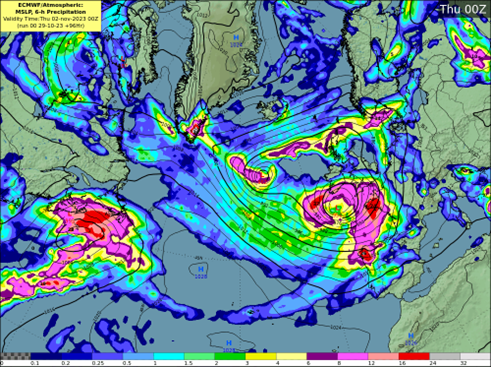
"The ground is saturated or waterlogged. The river levels remain high and there is a lot of surface water. With the recent super moon high tides remain an issue for the south and east of Ireland", she said. MORE BELOW PICTURE.
The meteorologist said that there'd be some respite on Tuesday, Halloween but things would deteriorate on Wednesday.
"Storm Ciarán potentially clipping the south and east of Ireland during Wednesday evening and for a time on Thursday," she said.
Beyond that, Ms Ryan said the weather forecast looks 'unfavourable'.
Met Eireann has issued a Weather Advisory for the days ahead.
"On Monday, Tuesday and Wednesday, there will be heavy showers or longer spells of rain at times over Ireland with flooding likely in places, as soils are saturated and river levels are high.
"Later Wednesday and on Thursday, Storm Ciaran will bring falls of heavy rain and strong winds. Current indications suggest the heaviest rain and strongest winds will be in Munster and Leinster with flooding likely," said the advisory.
Met Eireann says additional impacts are poor visibility and difficult and dangerous driving conditions.
The Advisory is valid from Sunday to Thursday night.
Met Éireann said Storm Ciarán was declared by its weather forecasting partner in the UK the Met Office. It follows on quickly from Storm Agnes and Strom Babet which caused bad flooding in Ireland and the UK. DETAILED FORECAST BELOW TWEETs.
#StormCiarán has been named and is forecast to bring very strong winds and heavy rain to southern parts of the UK on Wednesday night and into Thursday
— Met Office (@metoffice) October 29, 2023
Stay #WeatherAware pic.twitter.com/wC1NxowSoW
⚠️ Yellow weather warning issued ⚠️
— Met Office (@metoffice) October 29, 2023
Heavy rain associated with #StormCiarán with further disruption likely
Wednesday 1800 – Thursday 2359
Latest info https://t.co/QwDLMfS950
Stay #WeatherAware⚠️ pic.twitter.com/VdOox8IcD9
⚠️ Yellow weather warning issued ⚠️
— Met Office (@metoffice) October 29, 2023
Very strong and potentially damaging winds associated with #StormCiarán
Thursday 0000 – 1800
Latest info https://t.co/QwDLMfS950
Stay #WeatherAware⚠️ pic.twitter.com/FGHlfFrXVu
MET Éireann National Forecast issued at 11.41am on October 30.
National Outlook Overview: Very unsettled with showers and spells of heavy rain bringing the continued risk of flooding. Storm Ciaran is expected to track to the south of Ireland on Wednesday night and Thursday.
Monday: A mix of cloudy periods and scattered showers today with some isolated sunny spells at times too. Some of the showers will be heavy and prolonged with the risk of thunder and spot flooding. Highest temperatures of 10 to 13 degrees with generally light breezes, fresher in the north.
Further showers in places overnight with the chance of some heavy downpours, especially across the northern half of the country. Areas of mist and fog will form as winds fall light. Lowest temperatures of 3 to 7 degrees.
Tuesday: A foggy start on Tuesday, Halloween, with some showers in Ulster. Mist and fog will gradually clear during the day with some sunny spells developing. However, rain will develop in the southwest before lunchtime, extending northwards over the country during the course of the afternoon and evening. Top temperatures ranging from 10 to 14 degrees in freshening southeasterly winds, mildest in the south.
Wet and blustery on Tuesday night with outbreaks of heavy rain bringing the possibility of localised flooding. Minimum temperatures of 8 to 11 degrees in fresh and gusty southeast winds.
Wednesday: Persistent rain will clear north Ulster on Wednesday to leave a day of bright spells and showers. Some of the showers will be heavy and prolonged and will be accompanied by a blustery southwesterly breeze. Becoming largely dry for a time towards evening with clearing skies. Highest temperatures of 10 to 13 degrees. On Wednesday night, Storm Ciaran is expected to track close to the south coast with a spell of heavy rain extending over much of Ireland, heavy in Leinster and Munster with the likelihood of some flooding. A strong east or northeast wind will develop also with the possibility of some very strong gusts. Lowest temperatures generally ranging between 3 and 6 degrees, coldest in Ulster.
Thursday: A wet and windy start in the east and south on Thursday with outbreaks of rain and strong and gusty north or northwest winds. Across western and northern counties, it will be somewhat drier with just a few passing showers. Rain will begin to clear from the east during the afternoon and evening with drier and clearer conditions extending from the west. Highest temperatures of between 8 and 11 degrees. Breezy on Thursday night with a mix of clear spells and showers. Lowest temperatures of 6 to 9 degrees in a fresh and gusty northwest breeze.
Friday: It looks set to be a bright and breezy day on Friday with sunshine and showers. Highest temperatures of 10 to 13 degrees in a fresh and gusty northwest breeze. On Friday night, it will start largely dry with clear spells and rather chilly with lowest temperatures of 4 to 7 degrees early on. However, later in the night, a spell of heavy rain is expected to spread from the south.
Weekend: Early indications suggest the weather will remain very unsettled for the weekend with further showers or longer spells of rain. It will be windy at times with areas of low pressure tracking near or over Ireland.

Subscribe or register today to discover more from DonegalLive.ie
Buy the e-paper of the Donegal Democrat, Donegal People's Press, Donegal Post and Inish Times here for instant access to Donegal's premier news titles.
Keep up with the latest news from Donegal with our daily newsletter featuring the most important stories of the day delivered to your inbox every evening at 5pm.
This publication supports the work of the Press Council of Ireland and Office of the Press Ombudsman, and our staff operate within the Code of Practice of the Press Council. You can obtain a copy of the Code, or contact the Council, at www.presscouncil.ie, Lo-call 1800 208 080 or email: info@presscouncil.ie.


