Search
26 Mar 2026
Search
26 Mar 2026
Please allow ads as they help fund our trusted local news content.
Kindly add us to your ad blocker whitelist.
If you want further access to Ireland's best local journalism, consider contributing and/or subscribing to our free daily Newsletter .
Support our mission and join our community now.
To continue reading this article, you can subscribe for as little as €0.50 per week which will also give you access to all of our premium content and archived articles!
Alternatively, you can pay €0.50 per article, capped at €1 per day.
Thank you for supporting Ireland's best local journalism!

Storm Éowyn

Met Éireann has extended its Status Red Storm Éowyn weather warning to Laois and neighbouring counties with the forecaster warning the public of a danger to Laois from what is set to be a historic weather event.
The forecaster included Laois and a host of other counties in its Status Red zone at about 3.10 pm on Friday, January 22 hours after the county was given an orange alert.
The County is part of a Status Red that includes Cavan, Monaghan, Dublin, Kildare, Laois, Longford, Louth, Meath, Offaly, Westmeath, Wicklow, Roscommon, Tipperary.
It says Storm Éowyn will bring gale to storm force southwest to west winds will bring severe, damaging and extremely destructive gusts in excess of 130km/h
The alert is valid from 6am to 12 noon on Friday.
The alert was issued: 15:10 Wednesday 22/01/2025
Status Red warning is issued when there are rare and very dangerous weather conditions from intense meteorological phenomena.
Met Éireann urges poeole to take action to protect yourself and your property in such circumstances. The public is asked to follow instructions and advice given by the authorities under all circumstances and be prepared for exceptional measures.
Met Éireann has also placed under a Status Orange wind warning along with the rest of Ireland. MORE BELOW PICTURE.
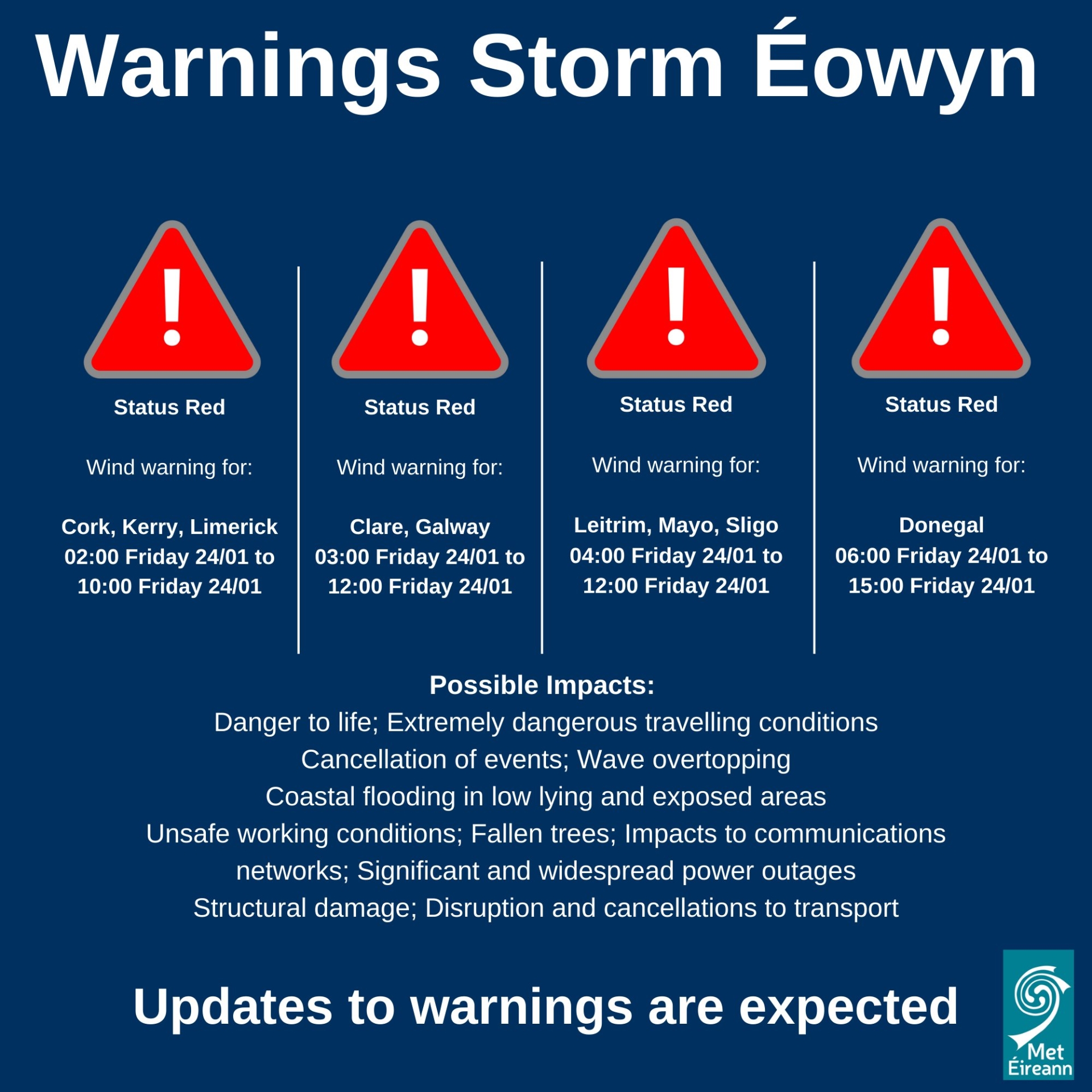
It warns of gale force southerly winds becoming westerly will bring severe, damaging and destructive gusts of up to 130km/h widely, with even higher gusts for a time.
It is val from 2am to 5pm on Friday, January 24.

Subscribe or register today to discover more from DonegalLive.ie
Buy the e-paper of the Donegal Democrat, Donegal People's Press, Donegal Post and Inish Times here for instant access to Donegal's premier news titles.
Keep up with the latest news from Donegal with our daily newsletter featuring the most important stories of the day delivered to your inbox every evening at 5pm.
This publication supports the work of the Press Council of Ireland and Office of the Press Ombudsman, and our staff operate within the Code of Practice of the Press Council. You can obtain a copy of the Code, or contact the Council, at www.presscouncil.ie, Lo-call 1800 208 080 or email: info@presscouncil.ie.


