Search
26 Mar 2026
Search
26 Mar 2026
Please allow ads as they help fund our trusted local news content.
Kindly add us to your ad blocker whitelist.
If you want further access to Ireland's best local journalism, consider contributing and/or subscribing to our free daily Newsletter .
Support our mission and join our community now.
To continue reading this article, you can subscribe for as little as €0.50 per week which will also give you access to all of our premium content and archived articles!
Alternatively, you can pay €0.50 per article, capped at €1 per day.
Thank you for supporting Ireland's best local journalism!

Laois Fire and Rescue Service clean up after storm.

Storm Éowyn will be 'historic' according to popular Carlow Weather man Alan O'Reilly who claims the weather charts are unprecedented.
With Met Éireann already issuing Status Red and Orange Weather warnings for Laois and other counties, the experienced weather observer has been updating the public via social media.
He said a weather model shows gusts "I’ve never seen this model show before for Ireland".
He continued in a post on x: "Anyone saying this is just another storm is in for a rude awakening. This will be a historic storm".
Mr O'Reilly expects the storm to be as powerful as Storm Ophelia and Storm Darwin.
Wednesday lunchtime update with latest models showing very damaging gusts Friday across the country with red warnings likely to be extended to more areas. #StormÉowyn pic.twitter.com/4rXfiAloGo
— Carlow Weather (@CarlowWeather) January 22, 2025
That high resolution AROME model out to 9am shows gusts I’ve never seen this model show before for Ireland and this model is one of the best there is for Ireland. Anyone saying this is just another storm is in for a rude awakening. This will be an historic storm. #StormÉowyn pic.twitter.com/qQSYYqsKSc
— Carlow Weather (@CarlowWeather) January 22, 2025
Hurricane Ophelia, known as Storm Ophelia in Ireland and UK, was regarded as the worst storm to affect Ireland in 50 years, and was also the easternmost Atlantic major hurricane on record. Met Éireann issued a national Status Red alert for the 2017 event.
Storm Darwin Ireland and the United Kingdom on February 2014. The storm brought widespread tree falls and road closures around Ireland, with damage to buildings reported across southern Ireland.
Met Éireann has issued Status Red alerts for counties from Donegal to Cork for the event.
National outlook from Met Éireann is that Storm Eowyn will bring powerful and disruptive winds over Ireland on Thursday night and during Friday along with some transient snowfall in the northwest.
National Forecast issued at 11.07am by Met Éireann on January 22.
Wednesday: Lingering mist and fog will clear from most areas today but may be stubborn to clear from parts of the north and northeast. Most parts of the country will be dry with a mix of cloud and sunny spells with just well scattered light showers. Highest temperatures of 4 to 9 degrees, coldest where fog lingers with mostly light southwest or variable breezes.
Rather cold overnight with some areas of fog and a slight frost in places. Later in the night, southerly winds will freshen clearing any fog and frost as outbreaks of rain arrive along the Atlantic seaboard. Lowest temperatures of 1 to 4 degrees.
Thursday: Thursday will be a blustery day as a band of squally and possibly thundery rain pushes eastwards across the country during the morning. Sunny spells and showers will follow from the west through the late morning and afternoon - some heavy with hail and isolated thunderstorms. Cool with highest temperatures of 4 to 8 degrees with fresh and gusty southerly winds, veering westerly. MORE BELOW PICTURE.
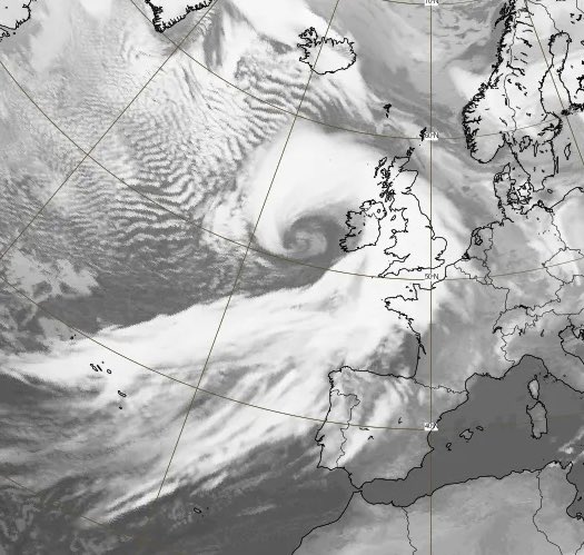
Expected scale of Storm Éowyn from satellite.
Becoming very stormy on Thursday night. Largely dry early on Thursday night with clear spells and perhaps a touch of frost. However, outbreaks of rain will move in quickly from the Atlantic, extending across much of Munster and Connacht before midnight, before spreading nationwide. The rain will turn to sleet and snow for a time in Connacht and Ulster with the potential for some temporary accumulations causing hazardous travelling conditions. Turning very windy with strong to gale force southeast winds, veering southerly overnight. It will turn extremely windy by dawn on Friday. Lowest temperatures of zero to +4 degrees.
Friday: The centre of Storm Eowyn will track just off the northwest coast on Friday morning with a swathe of extremely strong and damaging winds extending across the country bringing disruption. Gale Force southwest winds over land, will veer westerly by afternoon with Storm Force winds likely in some coastal areas. There'll be scattered squally showers and more persistent rain is likely across the north of the country. Showers will turn increasingly wintry as the day progresses. Maximum afternoon temperatures of 6 to 9 degrees but feeling much colder due to the wind-chill factor. On Friday night, winds will begin to abate but it will stay rather blustery. A cold night with clear spells and scattered showers, some wintry. Lowest temperatures of -2 to +3 degrees with some frost possible towards dawn on Saturday as winds continue to ease.
Saturday: A cold and frosty start on Saturday with sunny spells and a few wintry showers in the northwest. Later in the morning, an organised band of showers will push in from the Atlantic and extent eastwards across the country giving some wintry falls. Maximum temperatures of 3 to 8 degrees in moderate to fresh southwest winds. Cold and frosty on Saturday night with lowest temperatures of -3 to +2 degrees.
Sunday: It looks set to turn wet and windy on Sunday with outbreaks of rain spreading from the south. Maximum temperatures of 5 to 9 degrees in strong and gusty south to southeast winds with gales at the coast.
Weather Warnings from MET ÉIREANN for LAOIS HERE.

Subscribe or register today to discover more from DonegalLive.ie
Buy the e-paper of the Donegal Democrat, Donegal People's Press, Donegal Post and Inish Times here for instant access to Donegal's premier news titles.
Keep up with the latest news from Donegal with our daily newsletter featuring the most important stories of the day delivered to your inbox every evening at 5pm.
This publication supports the work of the Press Council of Ireland and Office of the Press Ombudsman, and our staff operate within the Code of Practice of the Press Council. You can obtain a copy of the Code, or contact the Council, at www.presscouncil.ie, Lo-call 1800 208 080 or email: info@presscouncil.ie.


