

All Met Éireann Storm Éowyn Status Red Weather Warnings

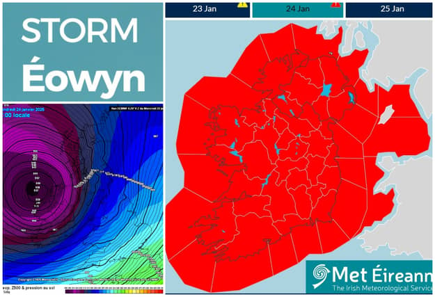

Eight Status Red Weather Warnings issued for Storm Éowyn by Met Éireann
Met Éireann has issued a total of eight Red Weather Warnings for all of Ireland that come into effect at various times from tonight through Friday. Red Weather Warnings are extremely dangerous and destructive and pose a danger to life.
Met Eireann warns that gale to storm force southerly winds will become westerly with extreme, damaging and destructive gusts in excess of 130km/h
Met Éireann warns that impacts of Storm Eowyn are Danger to life; Extremely dangerous travelling conditions; Unsafe working conditions; Disruption and cancellations to transport; Many fallen trees; Significant and widespread power outages; Impacts to communications networks; Cancellation of event; Structural damage; Wave overtopping; Coastal flooding in low-lying and exposed areas
As of 9am on Thursday, there are eight Red Weather Warnings in place from Met Eireann. There is also a Status Orange Wind Warning for all of Ireland from midnight until 4pm tomorrow.
The Status Red Weather Warnings are as follows.
A Status Red Wind warning for Carlow, Kilkenny, Wexford, Cork, Kerry, Limerick and Waterford from 2am on Friday until 10am on Friday.
A Status Red Wind Warning for Clare and Galway from 3am on Friday until 11am on Friday
A Status Red Wind warning for Leitrim, Mayo and Sligo from 4am on Friday until 12 noon on Friday.
A Status Red Wind warning for Cavan, Monaghan, Dublin, Kildare, Laois, Longford, Louth, Meath, Offaly, Westmeath, Wicklow, Roscommon and Tipperary from 6am on Friday until 11am on Friday.
A Status Red Wind Warning for Donegal from 7am on Friday until 2pm on Friday.
A Status Red Storm warning from Valentia to Erris Head to Fair Head and on the Irish Sea from midnight until 2pm on Friday.
A Status Red Storm warning from Fair Head to Wicklow Head to Valentia and on the Irish Sea from midnight until 2pm on Friday.
Status Red - Storm warning from Rossan Point to Malin Head to Strangford Lough and on the Irish Sea North of Isle of Man from 2pm on Friday until 7pm on Friday
The UK Met office has also issued a Status Red alert for NORTHERN IRELAND FROM 10am to 5pm.
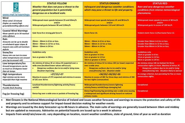
The Met Éireann Status Red Weather Warning Storm Éowyn warn of gale to storm force southerly winds becoming westerly with extreme, damaging and destructive gusts over 130km/h
The impacts are likely to be:
• Danger to life
• Extremely dangerous travelling conditions
• Unsafe working conditions
• Disruption and cancellations to transport
• Many fallen trees
• Significant and widespread power outages
• Impacts to communications networks
• Cancellation of event
• Structural damage
• Wave overtopping
• Coastal flooding in low-lying and exposed areas
Forecasters expects the storm to be as strong as Storm Ophelia in 2017 which was originally a hurricane.
More at www.met.ie