Search
06 Dec 2025
Search
06 Dec 2025
Please allow ads as they help fund our trusted local news content.
Kindly add us to your ad blocker whitelist.
If you want further access to Ireland's best local journalism, consider contributing and/or subscribing to our free daily Newsletter .
Support our mission and join our community now.
To continue reading this article, you can subscribe for as little as €0.50 per week which will also give you access to all of our premium content and archived articles!
Alternatively, you can pay €0.50 per article, capped at €1 per day.
Thank you for supporting Ireland's best local journalism!


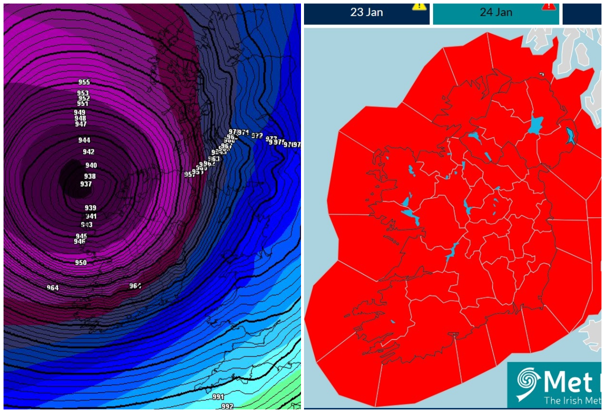
Met Éireann Storm Éowyn weather stations show 100 kmph winds offshore with the storm already causing near 100 kmph gusts as it nears Ireland.
The weather forecaster's weather stations and bouys are confirming the expected strength of the storm as it barrels into Ireland.
Buoys off the south coast show that the wind gusts are exceeding or have hit or exceeded 100 kmph in high seas of the west and Cork coasts.
Latest reports from Met Éireann weather stations show gusts of over 100 kmph in Cork and Kerry at 10pm.
Windy.com shows winds of nearly 140 kmph near the centre of the storm in the Atlantic.
Met Éireann forecast issued at 9.30pm on Wednesday said that Storm Eowyn would bring severe or extreme southeasterly to southwesterly winds overnight, with destructive and damaging gusts.
It said violent storm-force winds will occur near the southwest and west coasts.
It warned that the impacts would be severe with power outages and significant disruption due to falling trees and structural damage. A spell of heavy rain will continue to track northeastwards across the country with localised flooding, especially for southern counties.
There'll be some transient sleet and hill snow in Connacht and Ulster. The rain will clear to the northeast, but showers will follow, and with more rain moving into northern areas. Lowest temperatures of 1 to 6 degrees generally for a time, but turning milder from the south. MORE BELOW PICTURE.
Met Éireann warned that Storm Eowyn would continue to bring severe or extreme southwest to west winds, with destructive and damaging gusts. The forecaster said violent storm force winds would occur for a time near west and northwest coasts. He said impacts woull be severe with power outages and significant disruption due to falling trees and structural damage.
The forecaster said scattered squally showers with longer spells of rain across the north of the country. Highest afternoon temperatures of 5 to 8 degrees but feeling much colder due to wind-chill. The winds will ease from the south through the afternoon and evening.
The outlook is for winds to continue to ease and will become light to moderate Friday night. A cold night with clear spells and scattered showers, some of sleet and snow. Lowest temperatures of zero to plus 2 degrees with some frost possible towards dawn on Saturday.

Subscribe or register today to discover more from DonegalLive.ie
Buy the e-paper of the Donegal Democrat, Donegal People's Press, Donegal Post and Inish Times here for instant access to Donegal's premier news titles.
Keep up with the latest news from Donegal with our daily newsletter featuring the most important stories of the day delivered to your inbox every evening at 5pm.
This publication supports the work of the Press Council of Ireland and Office of the Press Ombudsman, and our staff operate within the Code of Practice of the Press Council. You can obtain a copy of the Code, or contact the Council, at www.presscouncil.ie, Lo-call 1800 208 080 or email: info@presscouncil.ie.


