Search
12 Dec 2025
Search
12 Dec 2025
Please allow ads as they help fund our trusted local news content.
Kindly add us to your ad blocker whitelist.
If you want further access to Ireland's best local journalism, consider contributing and/or subscribing to our free daily Newsletter .
Support our mission and join our community now.
To continue reading this article, you can subscribe for as little as €0.50 per week which will also give you access to all of our premium content and archived articles!
Alternatively, you can pay €0.50 per article, capped at €1 per day.
Thank you for supporting Ireland's best local journalism!

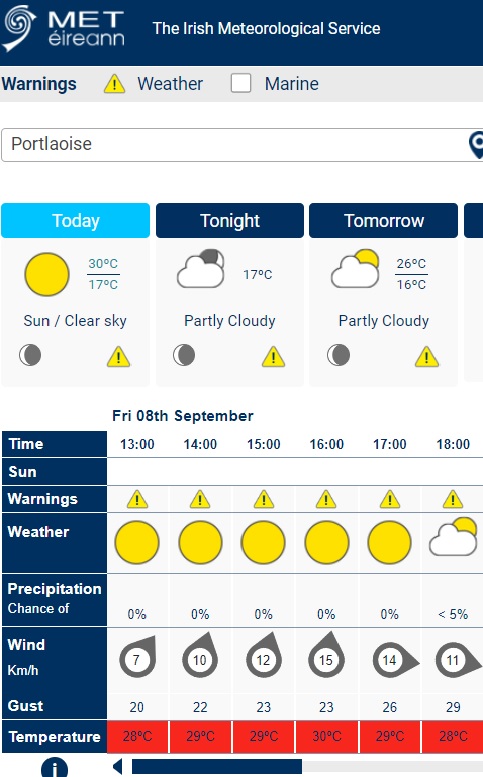
A Met Éireann chart shows the potential for Laois to break the temperature record for the hottest September day in Ireland.
The current top mark for September in Ireland is 29.1C and that was reported in Clongowes, Co Kildare in September 2009.
Met Éireann has forecast that this could be broken on September 8, with the Midlands with Laois one of the candidate counties to set the new high bar for heat in the first month of Autumn.
While the average temperature nationally and in Leinster is due to peak at 28 degrees on Friday, the homepage on the forecaster's website displays a graphic with hourly temperatures by local area.
It shows the temperature in Portlaoise peaking at 30 degrees in Portlaoise at around 4pm. The Laois Weather website which records live temperatures in Laois and is referenced by Met Éireann showed temperatures at 26 degrees at 1pm.
The forecaster said 14 out of its 25 primary weather stations have broken their September maximum temperature records over the past three days. Met Éireann expects more September records to fall on Friday.
The Met Éireann Weather Status Yellow alert warns of very warm and humid weather on Thursday and Friday. Daytime temperatures in excess of 27 degrees in many areas away from coasts with night time temperatures not falling below 15 degrees. Potential impacts:
• Heat stress
• Uncomfortable sleeping conditions
• Risk of water related incidents
It is valid until 8am on Saturday, September 9.
The weather outlook from Met Éireann is for the weather to stay very warm and humid with sunny spells and occasional thundery downpours. However, it will become cooler from Monday onwards.
MORE BELOW GRAPHIC.
More below post.
14 out of 25 primary weather stations have broken their September Maximum Temperature records over the past 3 days. More September records may fall today pic.twitter.com/dAyMI1LrOb
— Climate Services @ Met Éireann (@METclimate) September 8, 2023
National Forecast issued at 11:41am on Friday, September 8 by Met Éireann
Friday: Sunny day with highest temperatures of 24 to 28 degrees, possibly higher in a few places. Mist and fog may linger on the south coasts Isolated thunderstorms may develop inland during the afternoon. Light variable or southerly breezes.
Warm and humid night. It will be mainly dry with low cloud and areas of mist and fog, along with isolated showers. Lowest temperatures of 15 to 17 degrees in light southerly breezes.
Saturday: Mostly sunny again tomorrow, increased chance of isolated thunderstorms. Mist or fog may affect some coastal areas. Highest temperatures of 21 to 26 degrees with light ssouthwest or variable winds.
Mild and humid overnight with clear spells and isolated showers, possibly heavy or thundery. Lowest temperatures of 14 to 17 degrees with patches of mist and fog forming in near calm conditions.
SUNDAY: Another warm day with sunny spells and showers, some heavy with thunderstorms and spot flooding possible. Not quite as warm as previous days with highest temperatures of 19 to 24 degrees, with light variable breezes.
Showers in the east will largely die out overnight. Further spells of rain will move into the northwest and slowly track southeastwards. Lowest temperatures of 13 to 16 degrees with light westerly breezes.
MONDAY: Becoming mostly cloudy through the day with outbreaks of rain moving southeastwards across the country and clearing later in the day. This rain will be followed by cooler, less humid air. Highest temperatures will range from 15 to 19 degrees with light westerly breezes.
TUESDAY: Tuesday will likely be mostly dry with sunny spells. Feeling cool with highest temperatures of 14 to 17 degrees. Light northerly breezes.

Subscribe or register today to discover more from DonegalLive.ie
Buy the e-paper of the Donegal Democrat, Donegal People's Press, Donegal Post and Inish Times here for instant access to Donegal's premier news titles.
Keep up with the latest news from Donegal with our daily newsletter featuring the most important stories of the day delivered to your inbox every evening at 5pm.
This publication supports the work of the Press Council of Ireland and Office of the Press Ombudsman, and our staff operate within the Code of Practice of the Press Council. You can obtain a copy of the Code, or contact the Council, at www.presscouncil.ie, Lo-call 1800 208 080 or email: info@presscouncil.ie.


